SPATIO-TEMPORAL ANALYSIS OF RAINFALL DISTRIBUTION AND VARIABILITY OVER THE DROUGHT ? PRONE TAHSILS IN JALGAON DISTRICT OF MAHARASHTRA STATE
Abstract
Author(s): Patil Namdeo Arjun, Suryawanshi Dnyaneshwar Shivaji and Kate Asha Madhukar
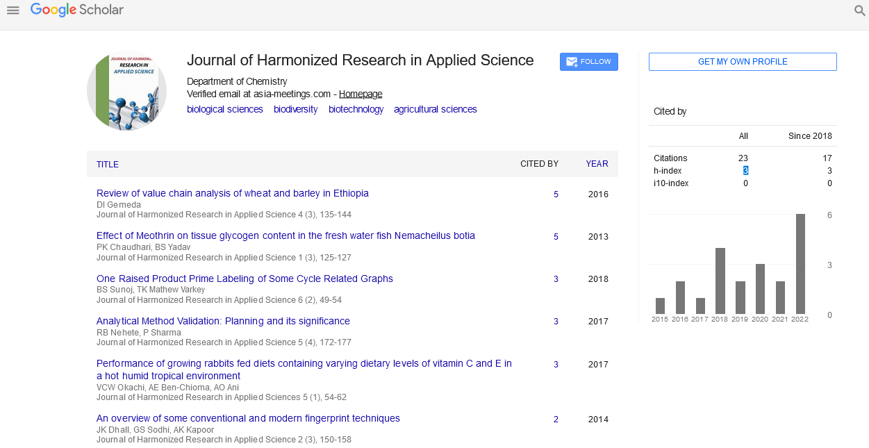
The study area is located in the drought-prone areas of Jalgaon district in North part of the Maharashtra state- The major occupation of the people in this region is farming which is mostly rainfed, whereas inter annual and seasonal variability is high and droughts are frequent in this region. Crop production in this semi-arid region is largely determined by climatic and soil factors. Rainfall is the limiting factor in these areas. It governs the crop yields and determines the choice of the crops that can be grown. Therefore, a detailed knowledge of regime is an important prerequisite for agricultural planning. Analysis of rainfall of the study is based on 31 years (1980-2010) of monthly, seasonal and annual rainfall data for a 9 rain gauge stations. While analyzing the long-term average of monthly and annual rainfall, the annual rainfall of the study area is 682.78mm, of which the winter, summer, southwest and northeast monsoon record 6.12, 14.29, 594.37 and 68.00mm respectively. The station, Amalner receives the highest rainfall of 1639.6mm in the year 1992, whereas Erandol records the lowest of 267mm in the year 1982. The region receives the highest average rainfall of 1082.11mm in the year 1998 and lowest average rainfall of 444.73mm in the year 2000. The annual variability ranges from 23% to 37%. The southern part of the region experiences the heavy rainfall, whereas the west, north, northeast part of the region experiences the lowest rainfall. The shaded region shows significant correlation coefficient with 5% level of significance.